This week's sunny weather is due to come to an abrupt end on Friday, with forecasters issuing two warnings for thunderstorms and heavy showers.
The Met Office has issued two yellow warnings for Friday, between midday and 8pm and Saturday from 1am, for thunderstorms and heavy rain, which could cause some disruption.
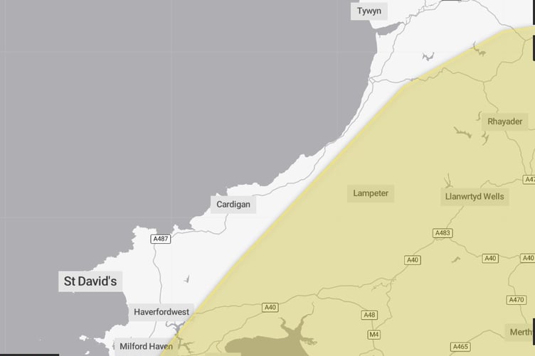
Friday's warning covers mid and south Wales, but does not stretch to coastal areas along Cardigan Bay.


-(2).jpeg?width=209&height=140&crop=209:145,smart&quality=75)

The yellow warning says: "A few thundery showers may be present across southern and southeast England early on Friday, but from the middle of the day they are expected to develop more widely within the warning area. Whilst some places will remain dry, where thundery showers do occur, they will bring frequent lightning, gusty winds, potentially some large hail, as well as brief spells of heavy rain.
"15-25 mm of rain fall may fall within an hour, with a very small chance of 30-40 mm falling in 3 hours; the latter most likely across southwest England. Showers will tend to ease and fade during Friday evening."
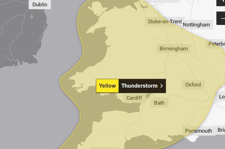
Saturday's warning covers all of Wales and runs from 1am until midnight, with forecasters unsure at present which areas will see the worst of the weather.
The Met Office says: "Whilst there is some uncertainty in the details , scattered showers and thunderstorms are likely to develop and spread northwestwards at times later on Friday night and through Saturday.
"While much of the time it will be dry, and not all places will see these, where they do occur 20-40 mm could fall in less than an hour, with a small chance of isolated accumulations of 50-70 mm over the course of a few hours.
"In addition, hail and frequent lightning may accompany the most intense storms, especially during Saturday afternoon and evening in parts of the Midlands, southern England and east Wales."
Met Office Chief Meteorologist, Neil Armstrong, said: ““Thundery downpours are expected to develop in places across the south on Friday afternoon bringing frequent lightning, gusty winds, hail, and spells of heavy rain.
“The risk of thunderstorms persists into Saturday with potentially longer spells of heavy rain for some along with a continued risk of hail and lightning accompanying the most intense storms, particularly in parts of the Midlands, southern England and east Wales during Saturday afternoon and evening.
“The warnings cover the areas of the country most at risk of seeing thunderstorms but not everyone within a warning area will experience a thunderstorm. For many much of the time it will remain dry.
“We are also expecting these showers to merge into longer spells of heavy rain on Sunday and Monday across some southern and central parts, and once the full details become clearer, we may well issue further severe weather warnings so keep up to date with the latest forecast for your area”
This change to more unsettled weather will also see a downturn in temperatures, particularly as we go into next week.
Further Ahead
We are expecting a window of drier conditions for most places on Tuesday before wet and windy, ‘autumnal’, weather once again moves across the UK from the North Atlantic.
Comments
This article has no comments yet. Be the first to leave a comment.