Natural Resources Wales is showcasing how satellite technology is playing a key role in the monitoring of the restoration of Wales’s lowland raised bogs.
The LIFE Welsh Raised Bogs Project is using the latest technological techniques, with the support of the UK Centre for Ecology & Hydrology (UKCEH), British Geological Survey (BGS), and the University of East London, to monitor the impacts of its restoration work and support peatland restoration.
Conventional on-the-ground monitoring of habitat condition, particularly in peatlands where conditions underfoot can be difficult, is time-consuming, expensive and requires staff with specific botanical skills.
The LIFE project is currently using several methods of Earth Observation (EO) techniques to help with monitoring the work, these are LiDAR (Light detection and ranging) and InSAR.
Jennifer Williamson from the Centre for Ecology and Hydrology said: “Although it is not currently possible to fully replicate on the ground monitoring methods with the use of Earth Observation, it does give an estimate of habitat condition on a 3D scale.”
Using satellite technology, the LIFE project has identified peatland areas in need of urgent restoration.
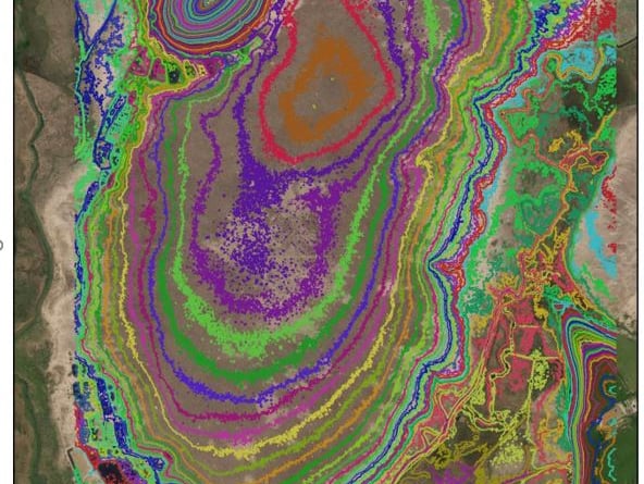
LiDAR images have been created of Cors Caron and Cors Fochno raised bogs.
Both these images have helped the LIFE team plan and place the low contour bunds (banks of peat) on the bog. The bunds have been built to follow the contour lines that the LiDAR maps show.
InSAR data is being used by the LIFE project to monitor Cors Fochno and Cors Caron’s surface movement over time. This method can be used to monitor peat subsidence or growth prior to and following restoration.
An InSAR image has been produced showing peat movement on Cors Caron West Bog, this image uses several satellite images layered on top of each other from 2015 to 2021.
The dark and lighter purple colours represent peat that is shrinking which is bad news for the bog. The colours show that the peat surface in the centre of the West Bog is dropping by 1cm a year.
The shrinkage is as a result of the bog getting drier, which will harm important bog plants and wildlife, and demonstrates why it’s so important to restore the bog by rewetting.
In the long term the data will also be used to demonstrate the effects of the work achieved and its impact on the peatland condition.
Jake White, LIFE Welsh Raised Bogs project manager said: “Satellite technology techniques allows us to monitor peatland condition at a scale that was unimaginable a decade ago, allowing peatland restoration progress to be measured in real time.”
Aerial photography is one of the more detailed methods of monitoring and can take images with a pixel size of a few centimetres. Traditionally, this would have been carried out by aeroplane, but now high-resolution images of sites can be obtained using cameras mounted on drones.


