Natural Resources Wales (NRW) is urging people to be alert for flooding this weekend as Storm Bert is expected to bring heavy, persistent rain and strong winds across Wales on Saturday and into Sunday.
Large swathes of Wales are expected to experience heavy rain, which could lead to surface water issues and cause rivers to rise rapidly – particularly as recent snowfall melts quickly.
A yellow Met Office warning for rain is in place for most of Wales from 6am on Saturday until 6am on Sunday. A yellow wind warning is also in place spanning the North West and West Wales coastlines between 5am and 7pm on Saturday.
NRW’s incident response teams are working with other emergency responders and local authorities, checking flood defences are in good working order and making preparations to help keep people and property safe.
People are being urged to consider any steps they may need to take now to be prepared, and to take extra care if you need to travel this weekend.
Katie Davies, NRW’s Duty Tactical Manager, said: “The predicted heavy rain and strong winds from Storm Bert, coupled with snowmelt is likely to cause disruption across Wales this weekend. – We’re advising people to keep up to date with flood alerts and warnings issued in their areas.
“Making sure you know what the situation is like where you live is really important. You can check your flood risk and the latest flood alerts and warnings on our website which is refreshed every 15 minutes.
“Our teams will be doing all they can to reduce the risk for communities, but if there is flooding we want to make sure people are doing all they can to keep themselves safe too. We urge people to keep away from swollen rivers, and not to drive or to walk through flood water – it is often deeper than it looks and contain hidden hazards.”

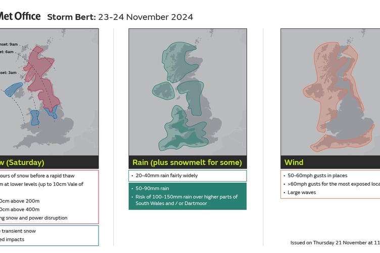
Jason Kelly is a Met Office Chief Meteorologist and said: “Storm Bert starts to arrive overnight on Friday and into Saturday, initially over Northern Ireland. As we go through the first part of Saturday morning, it will start to show its hand across Scotland, north Wales and northern England, with the potential for some heavy snowfall, especially over higher ground. Warnings are in place, including an amber warning for snow and ice for parts of Scotland.”
Storm Bert is also expected to bring heavy rain through Saturday and Sunday, especially in southern and western parts of the UK.
Jason said: “Heavy rainfall will affect much of the UK this weekend. Rain is expected to develop during Saturday morning across southwest and southern England, becoming particularly heavy and persistent overnight and into Sunday.
“Accumulations of 50-75 mm are expected to fall fairly widely during this time. There is a chance that some places over Dartmoor for example, could see 100-150 mm. In addition, rapid melting of lying snow over the weekend may bring flooding for some.”
Strong southerly winds will accompany the heavy rain, and warnings are in place in both the south and north. Gusts could peak at 50-60 mph in many parts of the warning areas, and could even reach in excess of 70 mph along some exposed coasts of Northern Ireland and western Scotland.
Jason Kelly said: “Storm Bert is what we call a ‘multi-hazard event’, bringing snow, rain and wind to the UK for the majority of the weekend. Multiple National Severe Weather Warnings are in place and will be added to and amended over the weekend. It’s possible this may be at short notice, so it is important people keep up to date with the very latest forecast.”


Comments
This article has no comments yet. Be the first to leave a comment.